

| Intro |
| Maps |
| Credits |
| Return To: |
| ATLSS.org |
 |
|
These pages present information for both the ATLSS Habitat Type Density Analysis, and a similar collection of habitat images for the Florida Department of Transportation (DOT) data. Section 1 : The ATLSS Habitat Type Density Analysis Maps.
The ATLSS Habitat Type Density
Analysis Maps (HTDAM) are derived from the maps created
by the Florida GAP analysis project (FGAP).
The FGAP maps provide information about the distribution
and abundance of habitat types within Florida.
We are currently showing here the results from both the
2.1 and 3.0 versions of the FGAP map.
The two versions also differ
in the number of habitat types included.
These habitat types represent a broad classification of
vegetation as well as urban and agricultural use.
The vegetation classification system used is The Nature
Conservancy's (TNC) Habitat classification system.
The 2.1 version of the FGAP map includes a total of 80
habitat types, 42 of which represent vegetation.
The 3.0 Version of the habitat map contains nearly 128
habitat types of which 82 represent vegetation.
In each case the remaining habitat types describe urban
and agricultural classifications.
Both versions of the FGAP
are represented by a raster map.
In each case, a single pixel in the map represents a
square on the ground 28.5 meters on a side.
For the 2.1 version of the map, this results in 9732
rows and 8220 columns, or a total of more than
7.9x10⁷ cells.
For the 3.0 version of the map, the area is covered by
16245 rows and 10067 columns for a total more than
1.6x10⁸ cells.
For each of these cells, the FGAP map contains a single
index representing the dominant habitat type present
within this area.
There is much more to know about the FGAP map and the
project in general.
For more information please visit
their web site
.
The ATLSS Habitat Type Density Analysis
takes the FGAP map and views it as a series
of separate maps, one for each habitat type.
This approach was taken to simplify the task of
visualizing the distribution and abundance of each of the
habitat types.
To attain this goal of simplifying visualization, a number
of processes have been applied to the original map.
The first thing you will notice
is that the HTDAM covers a smaller spatial extent than the original
FGAP maps.
This is a result of the focus and purpose of the ATLSS project.
Without getting into too much detail, ATLSS is primarily
focused on the area between the southern end of Lake Okeechobee
and the southern end of the Everglades National Park (ENP).
For more information about why ATLSS focuses on this region,
please see the ATLSS web site at
ATLSS.org. The second difference between the HTDAM and the FGAP images is the spatial resolution. The HTDAM is also a raster map, for which each pixel in the map represents a square on the ground 500 meters on a side. This resolution matches many of the ATLSS models. At this resolution it is also possible to see each pixel and still keep the overall map size manageable. In order to see every pixel of the 28.5x28.5 meter version of the FGAP, the map would need to be so large that it would be impossible to view the entire map at one time. The final and crucial difference between an FGAP map and the ATLSS HTDAM is that a FGAP map shows all habitat types at one time while the HTDAM shows a single vegetation type for each map. The approach taken in the HTDAM has a number of advantages. The FGAP map contains so much information that it is frequently difficult to see clearly the full extent of a habitat type, and difficult to understand how its density varies across the landscape. This is especially true of habitat types which exist at low densities within their distribution. These types occupy a small number of pixels relative to surrounding types and many be difficult to see. Even for types which are very common, near the edges of their distribution they may become very sparse, making them difficult to locate or distinguish from surrounding types which locally may be more abundant. By viewing each habitat type individually, it becomes clear how the density of the type varies within its range, and the extent of its distribution is easier to discern. This approach is not appropriate for all purposes, since information about how a type co-varies with other habitat types, both in density and distribution, is lost. However, for many purposes this mode of visualization is powerful and useful.
Drawn over the HTDAM maps in white are the outlines of some important management areas. These are provided as a means of reference. At the top of each HTDAM map is a short description of the habitat type being displayed. The associated number gives the index assigned to represent the habitat type in an FGAP map. The text gives the TNC description provided for that type. Note that the 3.0 and 2.1 versions of the FGAP map use different sets of indices, so type 23 in the 2.1 version of the map may not be type 23 in the 3.0 version. The black areas which appear in the HTDAM maps represent either ocean or areas not within an FGAP map. Section 2 : Habitat images for the Florida Department of Transportation (DOT) maps. In addition to the HTDAM, these pages include the images created for the Florida Department of Transportation map. The DOT map covers approximately the same area as the 2.1 version of the FGAP, but uses only 19 habitat types. The images which we have created from the DOT map are much simpler than the HTDAM maps. As in the HTDAMs, one map has been created for each habitat type appearing in the DOT map. However, the pixels for this map show only presence or absence. This means that there is no information about the fraction of a cell covered by a habitat type. The color of the pixels in these maps DO NOT correspond to the fraction of a cell covered. The color or each cell is the color used to represent the habitat type in the DOT map. The color black is used both to indicate absences of a habitat type from a particular area, and as the background color. A white outline of the area covered by the DOT map appears on each image to provide a frame of reference. The boundaries which appear in the HTDAM maps are not present in the maps created for the DOT data. The ATLSS project no longer makes use of the DOT map, There presence here are included only for completeness. We welcome any comments you wish to make about any aspect of these pages. If you encounter errors in our presentation, broken links, or simply wish to tell us what you think, please e-mail us at sylv@tiem.utk.edu. |
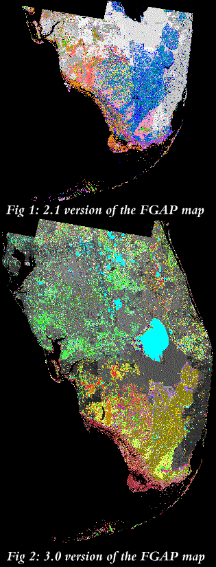 The two versions differ in a
number of respects, most notably in the geographical
extent of Florida included in the map.
Version 2.1 covers the entire width of Florida from
just below Lake Okeechobee south to the end of the
Florida Keys.
The 3.0 version expands the area covered further north.
This map's most northerly extent covers the area of
Lake Tohopekeligo, near Orlando, and extends south through
the Keys.
Figures 1 and 2 show the spatial extent of the two
version of the FGAP map.
The two versions differ in a
number of respects, most notably in the geographical
extent of Florida included in the map.
Version 2.1 covers the entire width of Florida from
just below Lake Okeechobee south to the end of the
Florida Keys.
The 3.0 version expands the area covered further north.
This map's most northerly extent covers the area of
Lake Tohopekeligo, near Orlando, and extends south through
the Keys.
Figures 1 and 2 show the spatial extent of the two
version of the FGAP map.
 For each habitat type present within
an FGAP map, there is one HTDAM map.
The cells of an HTDAM map are colored based upon the fraction
of the cell covered by a habitat type.
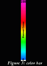
The relationship between cell color and frequency is given by the
color bar which appears on the right hand side of each HTDAM map.
The colors are graded continuously from blue through cyan, green,
yellow, red and finally magenta.
Cells colored blue contain very little of a given habitat
type, while cells colored magenta are completely covered by a habitat
type.
When a habitat type is not present within a cell, the cell is
colored grey.
Figure 3 show an example of the color bar as it appears in these
pages.
The color bar can also be seen at the top of this page, where
its location relative to this text is also its location relative
all HTDAM maps.
For each habitat type present within
an FGAP map, there is one HTDAM map.
The cells of an HTDAM map are colored based upon the fraction
of the cell covered by a habitat type.
The relationship between cell color and frequency is given by the
color bar which appears on the right hand side of each HTDAM map.
The colors are graded continuously from blue through cyan, green,
yellow, red and finally magenta.
Cells colored blue contain very little of a given habitat
type, while cells colored magenta are completely covered by a habitat
type.
When a habitat type is not present within a cell, the cell is
colored grey.
Figure 3 show an example of the color bar as it appears in these
pages.
The color bar can also be seen at the top of this page, where
its location relative to this text is also its location relative
all HTDAM maps.
 |
 |